


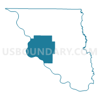
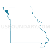
West Voting District, Holt County, Missouri
About
Outline

Summary
| Unique Area Identifier | 608032 |
| Name | West Voting District |
| County | Holt County |
| State | Missouri |
| Area (square miles) | 66.94 |
| Land Area (square miles) | 63.16 |
| Water Area (square miles) | 3.78 |
| % of Land Area | 94.35 |
| % of Water Area | 5.65 |
| Latitude of the Internal Point | 40.06757940 |
| Longtitude of the Internal Point | -95.32362880 |
Maps

Graphs
Select a template below for downloading or customizing gragh for West Voting District, Holt County, Missouri


Neighbors
Neighoring Voting District (by Name) Neighboring Voting District on the Map
- Arago/Barada Precinct, Richardson County, NE
- Central Voting District, Holt County, MO
- Jefferson/Rulo Precinct, Richardson County, NE
- Northwest Voting District, Holt County, MO
- Southwest Voting District, Holt County, MO
- White Cloud Township Voting District, Doniphan County, KS
Top 10 Neighboring County Subdivision (by Population) Neighboring County Subdivision on the Map
- Iowa township, Doniphan County, KS (1,641)
- Benton township, Holt County, MO (1,493)
- Union township, Holt County, MO (410)
- Forest township, Holt County, MO (353)
- Rulo precinct, Richardson County, NE (268)
- Bigelow township, Holt County, MO (200)
- Arago precinct, Richardson County, NE (164)
- Minton township, Holt County, MO (124)
Top 10 Neighboring Place (by Population) Neighboring Place on the Map
Top 10 Neighboring Unified School District (by Population) Neighboring Unified School District on the Map
- Falls City Public Schools, NE (6,044)
- Unified School District 111, KS (2,612)
- South Holt County R-I School District, MO (1,865)
- Holt County R-II School District, MO (1,802)
- Craig R-III School District, MO (730)
Top 10 Neighboring State Legislative District Lower Chamber (by Population) Neighboring State Legislative District Lower Chamber on the Map
Top 10 Neighboring State Legislative District Upper Chamber (by Population) Neighboring State Legislative District Upper Chamber on the Map
- State Senate District 12, MO (169,332)
- State Senate District 1, KS (69,919)
- State Senate District 1, NE (33,429)
Top 10 Neighboring 111th Congressional District (by Population) Neighboring 111th Congressional District on the Map
- Congressional District 2, KS (710,047)
- Congressional District 6, MO (693,974)
- Congressional District 1, NE (626,092)
Top 10 Neighboring Census Tract (by Population) Neighboring Census Tract on the Map
- Census Tract 201, Doniphan County, KS (2,308)
- Census Tract 9645, Richardson County, NE (1,775)
- Census Tract 9603, Holt County, MO (1,745)
- Census Tract 9602, Holt County, MO (1,735)
- Census Tract 9601, Holt County, MO (1,432)